Hiking the High Sierra Trail: 6 Days to the Summit of Mount Whitney
Quick Stats
Trail Name: The High Sierra Trail
Location: Sequoia National Park, California
Distance: ~70 miles (one-way)
Elevation Gain: ~16,427 feet (Alltrails)
Duration: 6 days / 5 nights
Difficulty: Challenging
Date Completed: July 2025
Permits Required: Yes – Sequoia NP wilderness permit for The High Sierra Trail
Start Trailhead: Crescent Meadow
End Trailhead: Whitney Portal (requires shuttle or second car)
Why I Chose This Trail
Ever since I moved to California, I’ve been pulled toward the Sierras. Towering granite peaks, remote alpine basins, trails that demand attention and effort. It’s everything I love about backpacking. This particular trail adds another element to the whole experience: the remoteness. There is a level of commitment that is appealing to me. Once you begin, the only real way out is up and over Whitney. I have been thinking about this trail since early 2024. I loved the idea of traversing Sequoia National Park on foot, while also summiting Mt. Whitney (tallest peak in the lower 48 states). It felt like the perfect way to push myself both physically and mentally. Also, this trip is also logistically challenging but totally doable.
I planned this trip for early July, with a buddy of mine that is based in Colorado. With a mild 2024/2025 winter, the snow had mostly melted, the creeks were still roaring, and the trail was just starting to fill with summer life. What unfolded over those six days was one of the most demanding and rewarding trips I’ve ever done.
Route Overview
The High Sierra Trail runs west to east across Sequoia National Park, beginning in the deep forests of Crescent Meadow and ending atop Mount Whitney at 14,505 feet. The trail offers immense variety, from deep river canyons to high alpine passes and serene backcountry lakes.
Key Milestones:
Day 0: Travel from SF to Visalia where our shuttle will pick us up
Day 1: Crescent Meadow to Bearpaw Meadow (~11 mi)
Day 2: Bearpaw to Big Arroyo (~13 mi)
Day 3: Big Arroyo to Kern Hot Springs (~11 mi)
Day 4: Kern Hot Springs to HST / Upper Kern Canyon Trail Junction (~8 mi)
Day 5: HST <> Upper Kern Canyon Trail Junction to Crabtree Meadows (~9 mi)
Day 6: Crabtree Meadows to Whitney Portal (~18 mi)
First Things First: Gear
Before we get into the day-by-day, let’s talk gear because on a trail like the High Sierra, what you bring (and what you don’t) makes all the difference. This was a fully self-supported, six-day trip through some of the most remote backcountry in California. Every ounce counted, and every piece of gear had to earn its place.
I spent weeks dialing in my setup, aiming for that elusive balance between going light and staying prepared. Given the remoteness and commitment of this route, I put more forethought into my kit than almost any trek before. This wasn’t a trail where you could afford to wing it.
Here were a few gear MVPs of the trip:
Hyperlite Junction 55"L – Ultralight, weather-resistant, and just roomy enough to carry everything I needed without compromise. Minimalist, but stored weight well. This was my first trip with this pack. Loved it!
Rab 20°F Down Sleeping Bag – Kept me warm through chilly alpine nights, even when temps dipped into the mid 30s.
NEMO Tensor Sleeping Pad – Lightweight, compact, and cushy enough to handle granite platforms and uneven terrain.
Big Agnes Flycreek HV UL1 Tent – A reliable, ultralight one-person shelter that stood strong against wind and occasional rain, while offering ample ventilation and easy setup.
Altra Lone Peak Trail Runners – Grippy, light, and blister-free over 70+ rugged miles. A no-brainer.
FYI - If you are curious, I am happy to share my full gear list. Just send over an email!
Clothing: Keeping It Simple
From a clothing perspective, I kept things pretty bare-bones. Knowing that if temperatures dropped too low, I could always rely on my 20-degree sleeping bag for warmth, I opted to travel light on apparel. My hiking kit included the essentials: an Outdoor Research Echo hoodie, a trusty North Face hat, Patagonia Quandary pants, and durable Darn Tough socks.
For sleeping, I switched to a Rab t-shirt, comfortable shorts, and an extra pair of socks, just enough to stay comfortable at camp without adding bulk to my pack. This minimalist approach worked well, letting me move freely on trail and rest easy at night.
All in all, my base weight was about 22lbs, plus 8-10lbs of food and water.
Day 0 – San Francisco to Visalia: Final Prep & The Launch Pad
Before we ever stepped foot on the trail, there was Day 0, which consisted of the drive in and our final gear check.
We left San Francisco in the late morning, making our first essential stop at REI to grab a few last-minute items. Most notably: a mosquito head net, which, in hindsight, turned out to be one of the MVP’s of the entire trip. The bugs were relentless most mornings on trail, and that net became my best friend over coffee and oatmeal.
From there, we hit the road for the La Quinta Inn in Visalia, where we planned to leave our car for the duration of the trip. Pro tip: call ahead and confirm that long-term parking is okay - hotel policies change, and you don’t want any surprises while you’re deep in the wilderness.
That night, we stayed at La Quinta and booked a 6:00 AM shuttle into Sequoia National Park through Sequoia Shuttle ($7.50 pp), which picks up directly from the hotel and drops you off in the park. After a final gear check, we repacked everything, laid out breakfast for the early morning, and called it a night.
Tomorrow, it would begin.
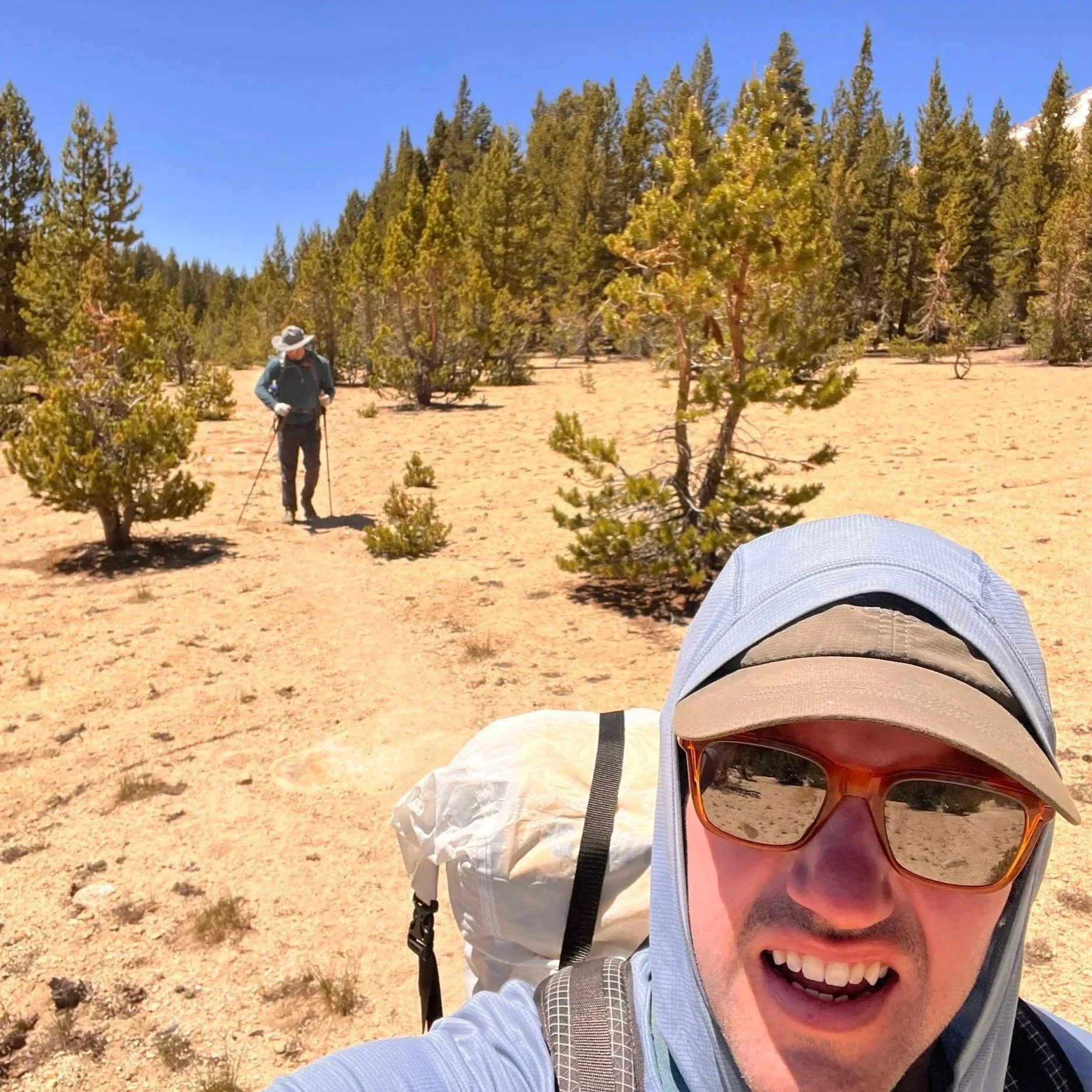
Day 1 – Visalia to Crescent Meadow to Bearpaw Meadow
The journey begins with a bright and early alarm, given that Sequois Shuttle service would be picking us up at 6am. Sure enough, they were right on time. We jumped in and off we go! It was about 2.5 hours before getting to the permit center Lodgepole. From here, we pick up our permit and head to the bus stop to take another shuttle to the trailhead. Meanwhile, we start talking with an older couple that are doing the trail together. Their pack was a womping 15lbs!! Their approach was to go super light and fast, while utilizing the bearboxes along the way.
Once we reach the trailhead, we unload and say goodbye to the last vehicle we would see for six days. Snapped a quick picture and we were on our way to Whitney!

Me (on the left) and Phil (on the left)about to hit the trail
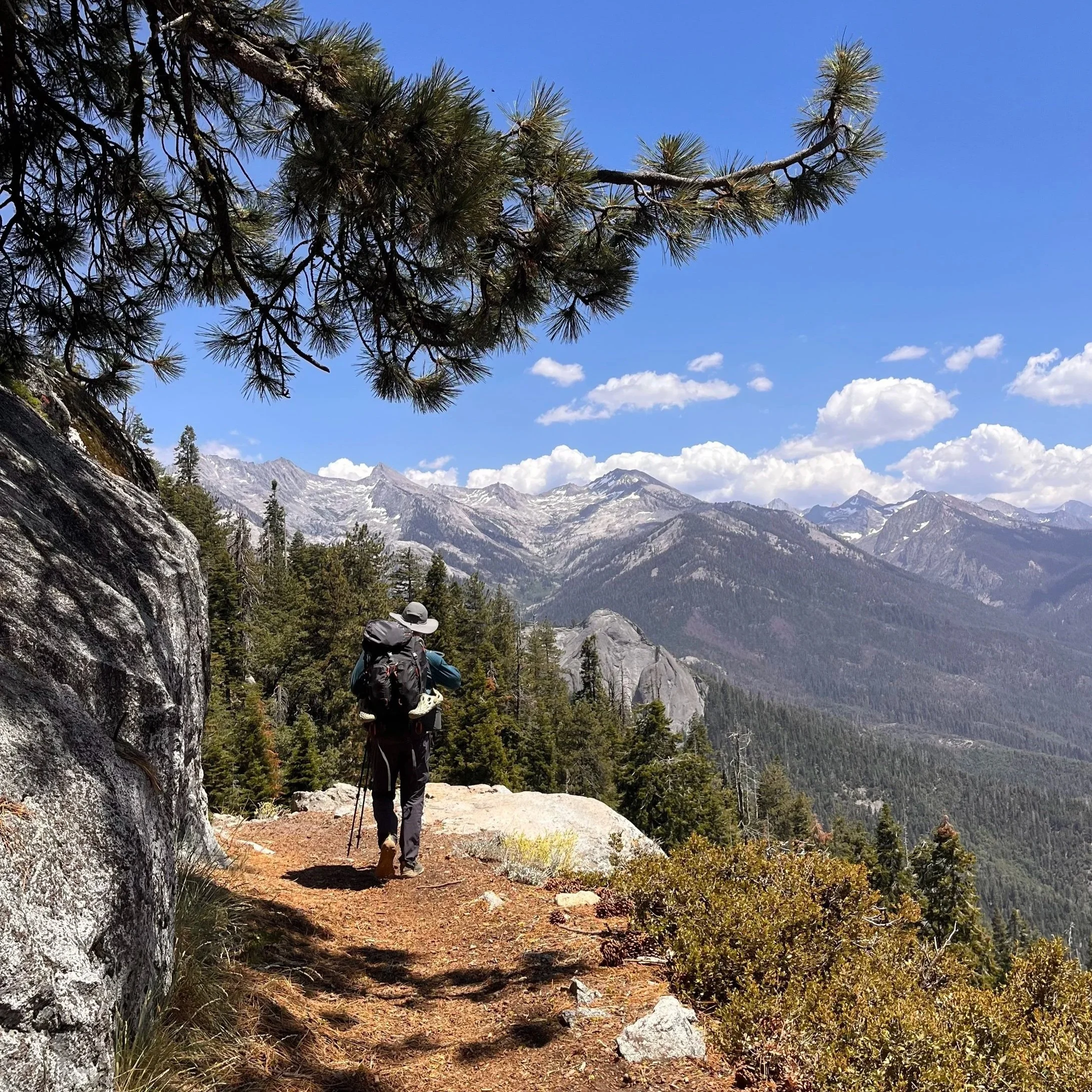
Knowing we had about 11 miles ahead to Bearpaw Meadow, we didn’t waste much time, so we hit the trail. Stepping out into the forest was an instant relief. After all the logistics and travel, it finally felt like the trip had started. The air was warm, and we almost immediately were rewarded with sweeping mountain views that reminded us why we came.
The trail gently rolled through towering sequoias, and along exposed ridgelines with jaw-dropping vistas into the Sierra backcountry. We stopped occasionally for water and snacks, but mostly just cruised on, getting used to our pack weight and pace.
Phil heading off to Great Western Divide
By late afternoon, we arrived at Bearpaw Meadow, where a handful of other hikers were already setting up camp. Tired but stoked, we pitched our tents, made dinner, and settled in as the sun dipped behind the trees. Day one was in the books, with Kaweah Gap looming over us.
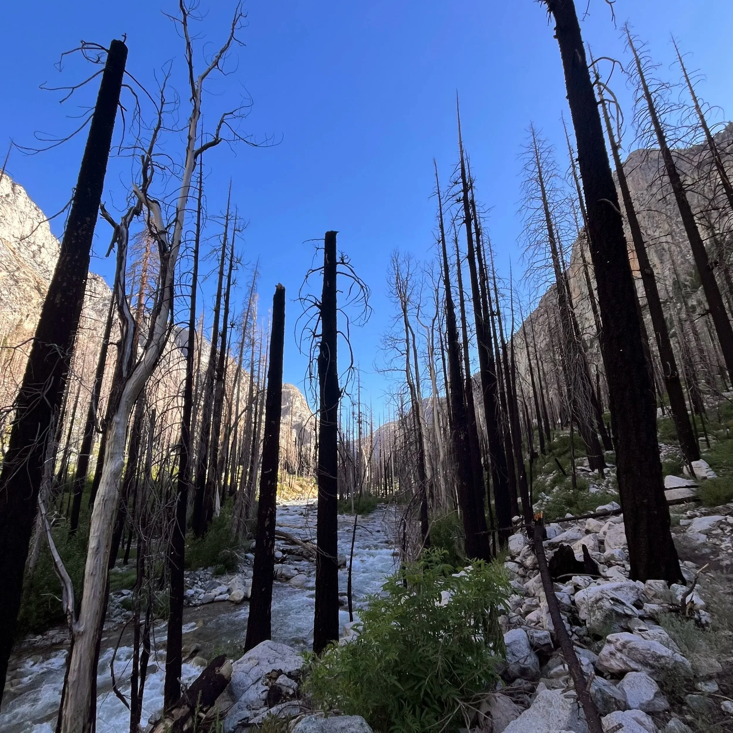
General thoughts: The first day is relatively moderate, with a steady climb and panoramic views across the Great Western Divide. It is worth noting, the water source at Bearpaw Meadow as sub-par. I recommend filling up at Buck Creek and porting it in.
Day 2 – Bearpaw to Big Arroyo
With Kaweah Gap looming ahead, we knew we had a big day in store. Alarms buzzed at 5:00 AM, and by 6:00 we were on trail, stepping into the quiet motions of the morning. The forest was still and it seemed that everything and everyone was still fast asleep.
The trail began gently enough, winding toward Hamilton Lakes. Moving river water, big granite walls, and crisp air made it tempting to linger but we had a pass to conquer. From there, the real climb began. The switchbacks stacked up quickly, and the effort set in. Heads down, it was one foot in front of the other.

Hamilton Lake and Kaweah Gap in the distance
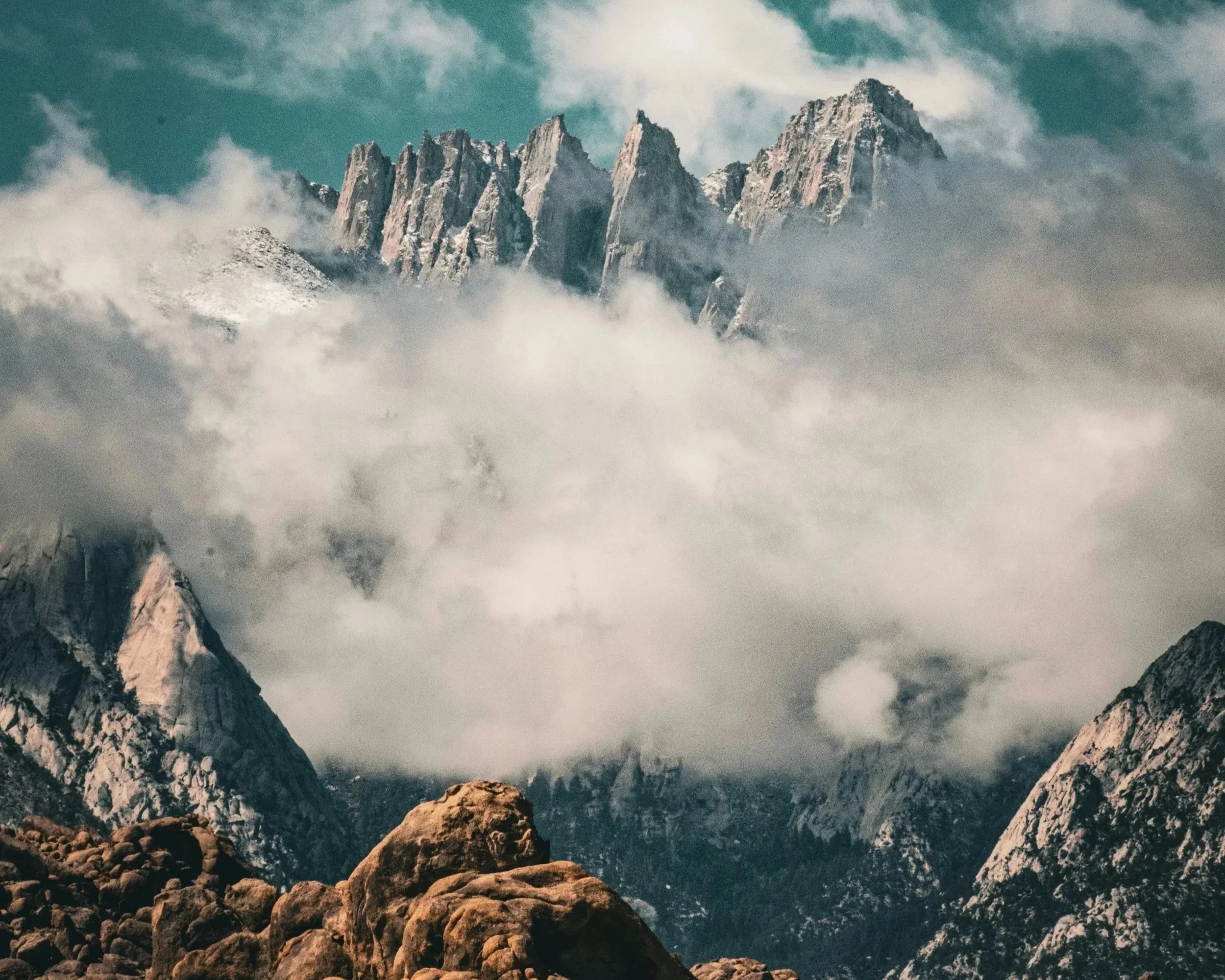
As we pushed past 10,000 feet of elevation, lingering snowfields forced some minor route-finding, but nothing sketchy. Eventually, we reached Precipice Lake, an otherworldly, alpine lake tucked beneath sheer cliffs. It felt like a reward in itself. After catching our breath and soaking it in, we made the final push over Kaweah Gap, the high point of the day and a major milestone. Once we reached the top, we were stoked. We have officially hiked over the Great Western Divide! The backside opened into a whole new landscape: expansive, remote, and wild.
The weather, famously unpredictable in the Sierra, held out beautifully for us - no afternoon thunderstorms or inclement weather. We continued a few more miles down, eventually finding a peaceful riverside camp just shy of the Big Arroyo junction. Day Two definitely hit harder than the first. We were still settling into our trail rhythm, but tucked deep in the backcountry, grateful and tired, it was impossible not to feel lucky.
Day 3 – Big Arroyo to Kern Hot Springs (+1 mile past)
Day Three brought a bit of a shift. Not just in terrain, but in the mosquito activity. Thank goodness for the bug headnets. Given that yesterday was a long day, we made a call to have a chill morning and exit camp around 10am. The morning air was crisp and quiet, and as we wound our way through the forest toward the Big Arroyo Junction, the mountains felt still and massive around us. It was at this point of the trail, were I noticed that there was not too many people on the HST. We were definitely getting out there!
Our route would take us out of the high alpine and begin a long descent into the Kern River Canyon - one of the most remote and dramatic parts of the entire trail. We passed through stands of pine, crossed creeks by rock hop and footbridge, and eventually began the steady drop toward the river. The terrain softened, becoming greener, more lush.
Hiking the switchbacks down to the Kern River
Eventually, we reached Kern Hot Springs, a legendary stop along the High Sierra Trail. But to be honest, we accidentally bulldozed past it looking for a camping area. Not too upset because we found an amazing camp spot right on the river past the popular hot spring area. Tucked away right beside the river, we found a place to call camp for the evening. The sun lowered, casting light on the canyon walls. It was something else! My legs were tired, but spirits were high. This was one of those days that made the entire trek feel worth it. The river raged through the night, as we were deep in the heart of the Sierras.
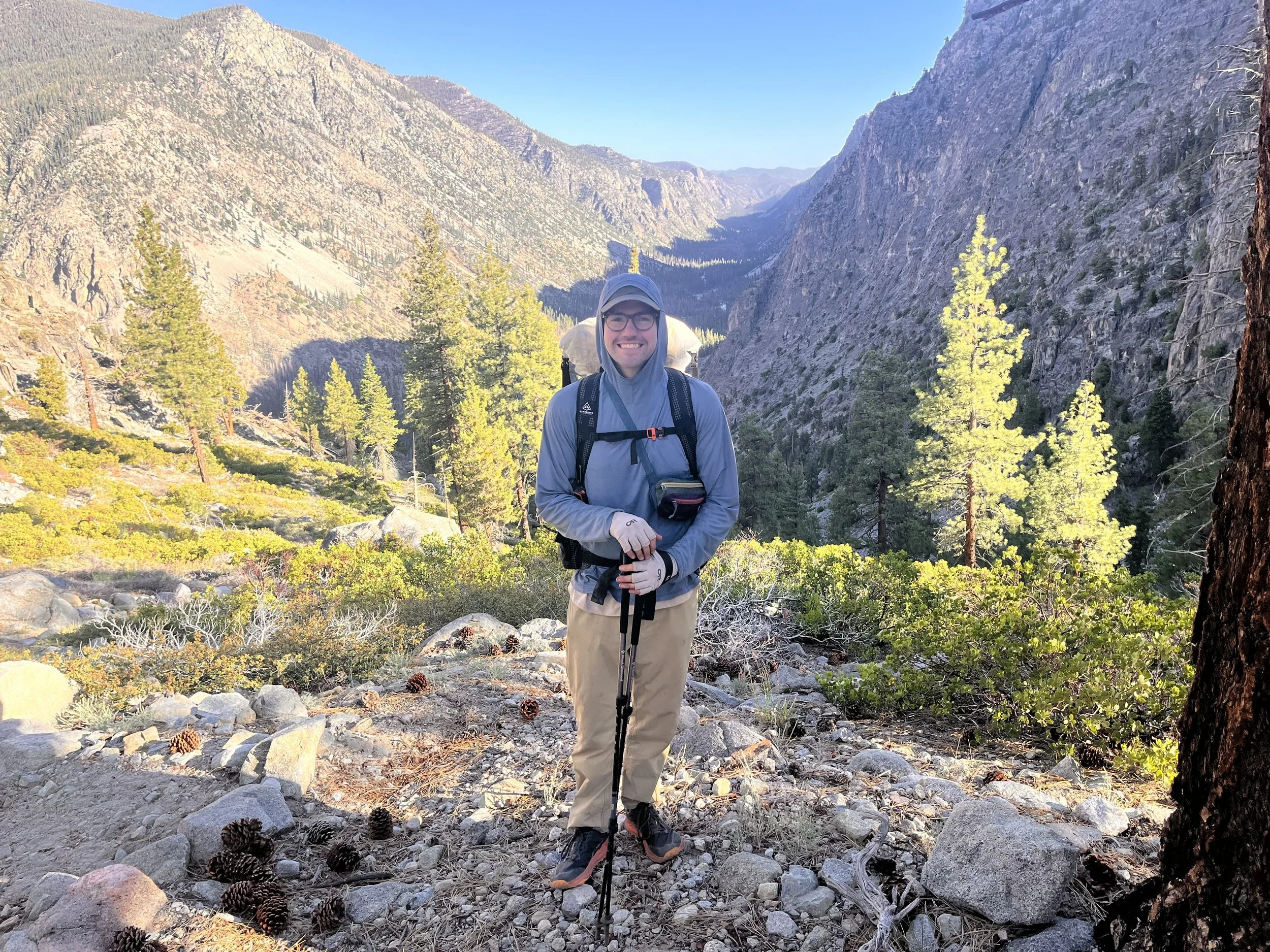
Day 4 – Kern to HST/Upper Kern Canyon Junction
Day Four was the most remote day of the entire trip - objectively as far out as we’d be. From here, our starting point at Crescent Meadow was well over 35 miles behind us. There’s a different kind of mindset that settles in when you reach that point at which turning back is no longer practical. It adds a layer of self-reliance you don’t always feel on more accessible trails. As Phil put it, this trip was a full on “immersion into nature“. True that!
The day was spent winding within the Kern River Canyon, a wild and rugged corridor etched by roaring water and framed by granite walls. We saw 1-2 other hikers throughout the entire day, and based on trail conditions, it was easy to tell this section hadn’t seen much traffic yet this season. We were climbing over downed trees every couple hundred feet, which added to the feeling that we were carving our way through something wild and untouched.
The Kern River
Eventually, we reached our first major river crossing, just before the Junction Meadow junction. The current was swift, and the water hit mid-thigh, but it was manageable. I never felt in danger, just a bit cold from the mountain water. We crossed one at a time, carefully, and pushed on up the climb to the HST/Upper Kern Canyon Junction.
We continued another half mile or so along the Upper Kern Canyon Trail until we found a solid camp beside the river. It was peaceful, beautiful, and surprisingly early - our earliest finish of the trip so far. After filtering water and getting some hot food, I was ready to crash. I was in my tent by 6:30 p.m., watching mosquitoes buzz under my rainfly. We were tired, but the position we’d gained today would put us in striking distance of the John Muir Trail tomorrow - one step closer to Whitney.
Day 5 – Junction to Crabtree Meadows
Day Five started with a big, sustained climb straight out of camp. Thankfully, we had the shade of the mountains for most of the morning, but still... this one kicked my butt. After five days of trekking with a loaded pack, plus creeping altitude, my body started to feel it. I was moving slowly, reminding myself that sometimes small forward motion is fast enough.
After a grueling stretch, we reached the junction. Finally, we made it to the John Muir Trail, a huge mental checkpoint. We dropped packs, hydrated, and let our heart rates settle. From this point, there was more climbing. Up, up, and away. Eventually the trail flattened out for a few miles, and we took advantage of the cruising. But it didn’t last.
By early afternoon, we found ourselves in a totally exposed, sun-baked section right as the day’s heat peaked. The trail was wide open, dusty, and hot. My body hit a wall. I could feel myself getting overexerted with a high heart rate, mild dizziness, and signs of dehydration. So we pulled off and regrouped. This is one of those moments when I really had to listen to my body. Out here, it’s all about making smart decisions that keep you safe.
Very exposed section of the trail before Crabtree Meadows
Our original goal for the day was to push to Guitar Lake, which would’ve put us in prime position to summit Whitney at sunrise the next day. But the way I was feeling, I just didn’t have it in me. We made the call to stop at Crabtree Meadows, and honestly, what a beautiful spot to land. It felt like the perfect place to rest and reassess.
As we set up camp, we started having a real conversation about our energy levels, food supply, timing, and our upcoming shuttle pickup. We didn’t officially scrap Whitney, but we did give ourselves permission not to go for it, if that is what we decided. The journey had already been incredible, and there was no need to force a summit just to say we did. We’d play it by ear in the morning.
After dinner, we hung around camp, and started prepping for the next day. Tomorrow was going to be big - whatever it held.
Day 6 – Crabtree Meadows to Mount Whitney Summit & Whitney Portal
Sleep didn’t come easy on my final night. My heart was pounding with a mix of altitude and nerves. Even if we bailed on summiting Whitney, we still had to climb nearly 2,800 feet just to get over Trail Crest (13,600 ft) and down to the exit. The weight of that reality kept me in and out of restless sleep all night.
Around 3:15 a.m., I stumbled out of my tent to use the restroom and spotted two headlamps bobbing away from camp. That was the spark. I wandered over to Phil’s tent, gently woke him up, and asked if he was down to move out early. It took a while to shake off the cold - it was one of the chilliest mornings of the trip but we bundled up, chugged water, and hit the trail around 4:30 a.m. Not much was said between us. Just the rhythm of shoes on dirt and headlamps casting narrow beams into the darkness.

Early morning alpine glow (you can see headlamps in the distance, climbing)
This was a classic alpine start, and we knew that we had some ground to make up after stopping short at Crabtree the day before. Slowly, the horizon began to glow. The granite peaks caught fire in the morning light. There’s something super special about those early hours on the trail. We reached Guitar Lake as the light crept across its glassy surface, signaling the beginning of the final push up the massive climb to Trail Crest. This section was relentless. Step after step, switchback after switchback, the air thinning with every breath. We didn’t speak much, just moved with focus, resting regularly, listening to our breath and our bodies.
And then, after hours of steady climbing, I saw it: Trail Crest Junction, at 13,600 feet. We had made it to the decision point. Left to the summit - another 1.9 miles. Right to descend the ~8 miles to Whitney Portal. I turned to Phil as he reached the ridge line, ready to talk it out. But before I could say a word, he looked at me and said, “We’re going to the summit.”
We had walked nearly 60 miles to get to this moment. We dropped our packs, grabbed some snacks and layers, and charged. The final stretch to Mt. Whitney's summit was slow, rugged, and surreal. But the encouragement from other hikers - those coming down, those going up - kept the momentum alive. We were all in it together, sharing one of the wildest, most beautiful experiences the lower 48 has to offer.
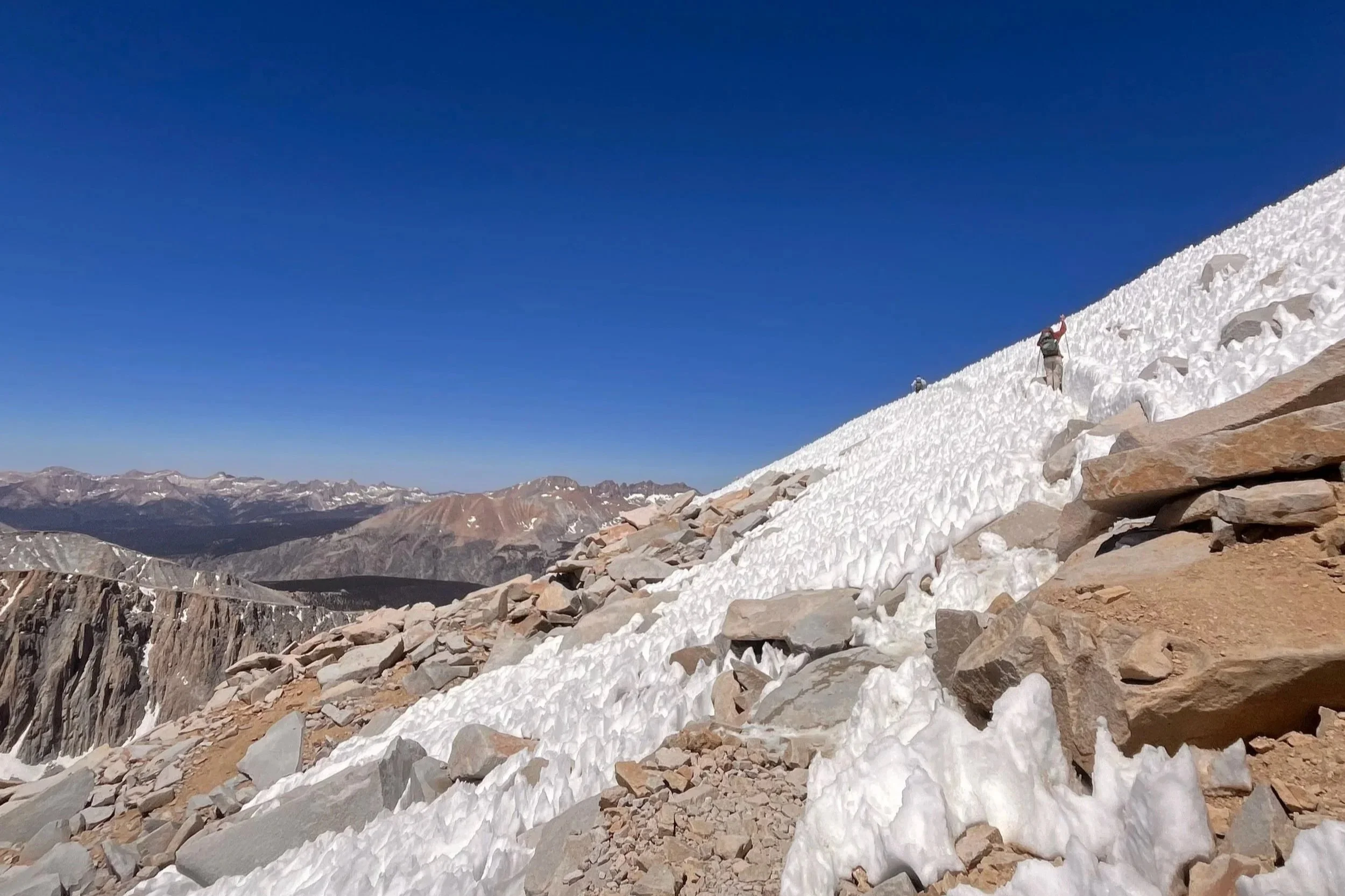
Pushing through the final snowfield
And then, we were there. At 14,505 feet, standing on the highest point in the lower 48 states. We signed the summit register - 07/08/2025 - and took it all in. Exhausted, proud, and fully present. Challenge accepted and completed.
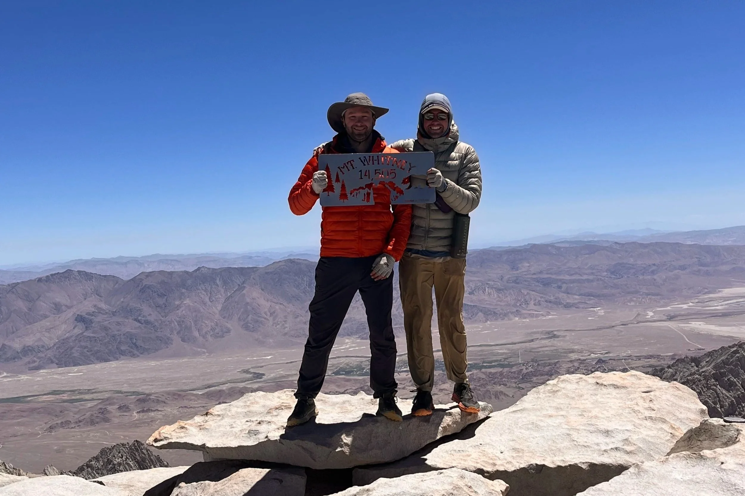
Summit!
After soaking up the summit views, we turned our attention to the long descent. Over 6,000 feet down to Whitney Portal, each step fueled by the promise of burgers, beers, and a ride back to civilization. The trail seemed endless, but we kept our heads down and marched on - stoked on our decision to push for the top and buzzing with the satisfaction of completing the entire High Sierra Trail from Crescent Meadows to Whitney Portal.
We came for an adventure and boy did find it. Cheers!